Sometimes getting there is half the
fun!
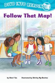
Pablo and his friends Henry, Lily,
Mei, and Padma (the kids present as Latinx, white, black, Asian, and South
Asian, respectively) decide to go to Coney Island as a fun way to end the
summer. Pablo’s dad, who, like his son, has brown skin, agrees to accompany the
children. “But how do we get there?” asks Lily. Pablo suggests that they use maps,
and then he excitedly plots out their journey: First they will walk to the bus
stop; then they will take a bus to the subway; then they will arrive at Coney
Island. A true cartophile, Pablo experiences a moment of worry that his friends
won’t “think it [is] fun to follow a map,” but his map-reading expertise ends
up helping the children be patient as they traverse the city. The best map of
all is the one that shows all of the fun rides on Coney Island. An activity
suggestion in the backmatter prompts readers to make maps of their own
neighborhoods, potentially extending this title’s use beyond its accessibility
and support of emergent-literacy skills and into the realm of map-reading, too.
As in her other work in this series, Ng-Benitez’s warm, engaging illustrations
help define the individual, diverse characters while creating a sense of
vibrancy and excitement in the urban setting.
For readers who are going places. (Early
reader. 5-7)


Add comment